And that’s another rough night around Galicia. We departed from Vigo at around 2 am, and the whole morning has been sleepless for me. After checking the roll amplitude on the dashboard, I realize it oscillates between 10 and 15 degrees! Concretely, it pulls me back when I’m going down steep stairs. And if I’m going up, these stairs look more like a wall.

There is quite a strong feeling of acceleration. The only accident with a passenger that the captain had witnessed was in these conditions. An old lady fell in her room. The 2nd officer says that they’d start to worry only of the roll exceeds 20°. I guess they have seen much worse, like in thisfilmati di un rullo di 40°.
In bed, it’s terrible. I’m under warm blankets, wanting to sleep more, but being moved all around, I can’t. It’s the same horrible feeling as when, in my tent, a fly or a mosquito roams around my ears or keeps landing on my nose.
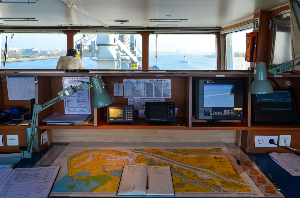
But once out of bed, it’s happiness. Watching the sunrise from the bridge, while my legs automatically counter balance the ship movement, is priceless. Then I sit in the captain’s seat, as if I was driving this steel monster, and it feels good.

We’re sailing alongside with several other vessels, probably heading to the Channel too. The expected storm in the Bay of Biscay, the English name for the Golfe de Gascogne, is fortunately not happening yet. The radar is now much more populated than before, and we race with Epic St John, Nounou and Flinter Rose. It’s like playing Counter Strike, some players are bad at picking names. The Automatic Identification System (AIS) shows who is going the fastest.


The chief mate tells me about calling stations in the Channel (La Manche). Every ship has to report to a calling station before entering the Channel, and wait for the authorization to enter. It happens only in heavy traffic areas, and considering the crew keeps comparing the Channel traffic with a ruthless and dangerous jungle, I guess this kind of traffic control is needed.
The calling station for us, arriving from the south west, is named Ushant … Ushant sounds like Ouessant, and it’s the same island! It’s the north-westernmost point of France, and I’ve been there as a kid. I still have postcards of the lighthouses surrounding the island on my bedroom walls. Unfortunately, we will pass 30 NM west from Ouessant, so it’s too far to see the island. Only smaller vessels are allowed to use a lane closer to it, or even sail east of Ouessant, in the dangerous Le Passage du Fromveur. Ships are not allowed to go wherever they want because of a Schema di separazione del traffico, which is like virtual lanes. It’s not a bad idea to be kept far away from the shores of Britanny, since after all, we carry uranium, and it’s proven that things si può sbagliare around here.

Nautical charts are becoming more interesting, since they have obviously much more information around the old continent than in the Atlantic ocean. There are many zones labelled “explosive dumping ground”, “firing practice area” or “submarine exercise area”. It would be great one day to dry up the Channel, so that we can go hiking on the sea beds, among fallen containers, wrecks, and all the secret army stuff dumped there.
The chief mate shows me a maritime guide book including pictures of lighthouses in the area … How nostalgic! Creac’h, Ar-Men, les Pierres Noires, la Vieille, Kéréon … I know them all. This region is certainly the world’s best for sorprendente fari.

I wake up at 6:30 on purpose to see Ouessant ’ fari s, since I had noted our ETA at the turning waypoint into Ushant’s maritime corridor was 6 am. I get on the bridge, look on my right, and instantly see a flashing red light, and white lights further right. It can’t be mistaken, it’s the PHARE du Stiff! There are two sets of white lights, the most powerful one must be the Creac ’ h, Europe’s (or the world’s) most powerful lighthouse. The other one could be Nividic.

We are at 48°50 N, a mere 25 nautical miles from the lighthouses (45km). I then go back to sleep for a few minutes, and miss breakfast. We’re now in the Channel, and there is no more swell. So the ship is quite stable, that’s why I slept well.


Wind blows at 30 knots against us and the weather is crap. Welcome to Normandie! We can see land, and that’s the French coast. Actually, it’s not France, but Alderney della Isole del canale, with the Faro Casquets, a white tower 10 NM from us. Cherbourg is just behind. My phone catches the UK signal. It’s weird that the first piece of French land visible on our route belongs to the UK.
Yet, the radio speaks with a french accent, it’s the Stazione di riva Jobourg. It doesn’t stand for Johannesburg. That station is in a town called Jobourg, at the tip of the Cotentin peninsula, and it’s not even a kilometer away fromLa Hague Areva sito di ritrattamento di combustibile nucleare. It’s the reporting station for all northbound vessels. The radio keeps talking and we hear what’s happening in the, say, 10 southbound and 10 northbound vessels in our immediate vicinity. As English is the official language for seamen, the officers tell me it’s very funny when they hear Filipino officers reporting to French stations. It already took me some time to understand what was “grisse-naize”. It refers to Gris-Nez, another reporting station, definitely not the most practical name for directing international traffic.
The Channel is always busy, but since we are now in winter with bad weather, the crew say it’s much easier than in summer time, when yachts, sailors and fishermen are all over the place, enjoying their right of way because they are smaller.

It’s the second time I see this kind of cargo, that looks like a huge floating building. It’s very high and all indoor. I would call it a floating fridge, but it is officially called a RORO, for roll-on/roll-off, because it carries cars. Only 15% of the hull is submerged, and vehicles drive directly into it. This one is the Perseo Leader, from the JapaneseLinea NYK, una societàof the Mitsubishi family, and can carry up to 7500 standard cars at once. The New York Times has published una storia molto interessanteand video about the Andromeda Leader, a sister ship from this one, explaining how they fit so many cars into it, and how quickly can the world be flooded with Japanese cars. NYK’s fleet of 120 RORO vessels carry in excess of 3 million cars per year across the globe.
The traffic is much more interesting now. Listening on the channel 16, the radio for distress calls, I hear heated conversations between huge cargo ships and tiny fishermen boats. The later have right of way, but the former has a fixed direction and cannot turn within less than half a mile. It’s like a fixed truck. Some ships are using the distress channel to chat, while a reporting station advertises their weather forecast there too. We also receive navtexts, saying that “gunning is ongoing” in certain areas. Working as an officer looked rather easy in the Atlantic, where we have been on autopilot for 5 days in a row, but it is looks stressing now.

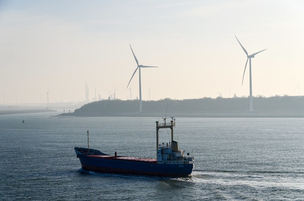
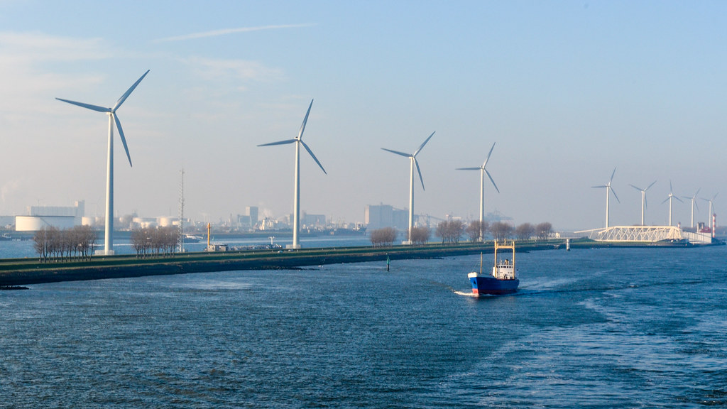
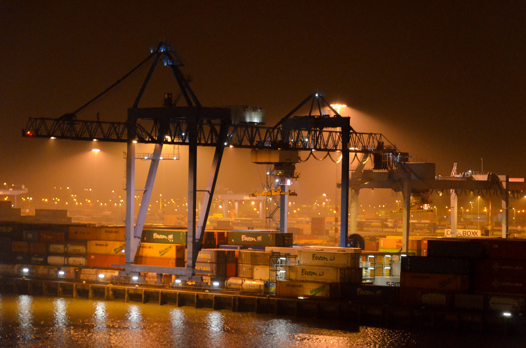
Boom boom boom boom, we arrive in Rotterdam, the hometown of the Vengaboys. The first human presence visible from the sea is the smoke from the chimneys of the Centrale elettrica Maasvlakte. This is an extension of the Europoort on reclaimed land, which is already an extension of the port of Rotterdam. The haze is thick and container cranes slowly appear altogether with wind turbines.
In the Channel up to the port of Rotterdam, between the two traffic lanes, there are beacon buoys. They are buoys equipped with a transponder that keeps emitting a letter in Morse code. That explains the strange signals on the radar. With latency settings long enough, the radar draws the Morse letter perfectly. Since the beacon buoys are also marked on the paper charts, with their ID letter, we can infer our position without referring to the GPS.

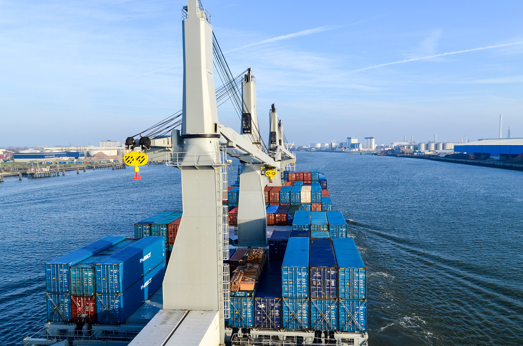
As I see people outside, walking on the beach of Hoek van Holland, I get out on the bridge deck with my camera. But instantly, the icy wind is freezing my fingers. Ouch! It’s a big drop of temperature. It was around 20°C in South Africa, around 30°C at sea, down to 15° in Spain, and now it’s close to 0°. The first days of December 2014 are exceptionally cold, and I didn’t need it at all. Despite frozen fingers, during the whole afternoon in the canals of the port, until our terminal, I will take 500 photos.

We are now inland, on the Delta del Reno-Mosa, sailing on the 14 to 16 meter deep canal called theNieuwe Waterweg, connecting the Scheurto the North Sea. A stone throw away from shore, on both sides. Our draft is 10 meter, so there is a 4 m margin at the bottom.
It’s great to arrive in a large city by waterways. Our final destination is 30 kilometers inland. From the bridge deck, it’s equivalent to being on the rooftop of a 200-meter long 5-story tall building slowly moving in a very large avenue. It feels like exploring a miniature city, as everything is smaller than us. And I see plenty of cyclists!


More than the industrial area on my right, the most interesting feature of the Nieuwe Waterweg canal is surely theMaeslantkering. It’s a storm surge barrier, i.e. a fence that protects the city of Rotterdam from being flooded by the North Sea. But because the canal is 360 meter wide, it makes a massive mobile fence.
Each of the two gates is 210 meter long and 22 meter high, and is said to weight twice as much as the Eiffel Tower. It is a massive piece of engineering, and it serves an equally massive goal: to save the Netherlands. Since over a quarter of the country lies below sea level, the Impianti di Deltaensure that disasters like in 1953, which saw 9% of total Dutch farmland flooded, do not happen again.
The pilot is on board and I guess the crew is excited to finally reach Europe. Most of them will be replaced when the ship reaches Hamburg, but we first unload the cargo (and myself) in Rotterdam.
Ilporto di Rotterdamis the largest port in Europe. From 1962 until 2002 it was the world’s busiest port. To show how small Europe is, today, 6 of the top 10 porti più trafficati di traffico di container are in China, relegating Rotterdam to the 11th position. The remaining 4 of the top 10 are also in Asia. The first Sub-Saharan African port is Durban, 54th. Ranked by cargo tonnage, Rotterdam is the world’s fifth, still behind the Chinese and Singapore.
The 2nd officer tells me that the port (or ports) of Shanghai, the world’s busiest, is too big and too far from the city, so rather annoying for the crew. He adds that Rotterdam and Hamburg are still the most efficient in his eyes, with the most skilled container crane operators, that would start unloading containers even while the ship is mooring.


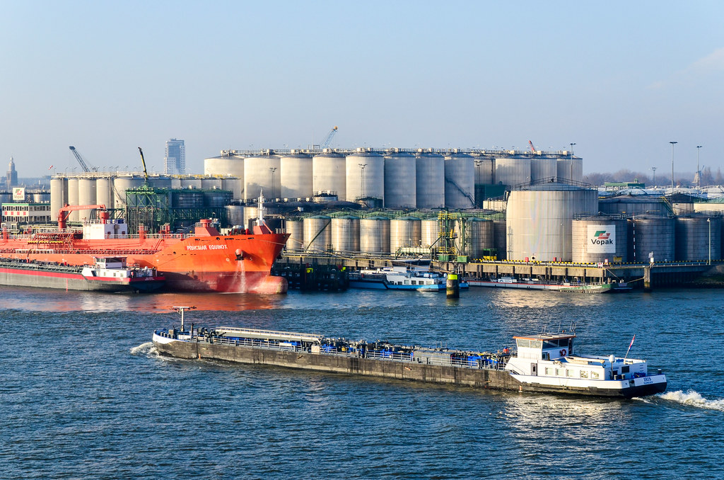
The port stretches over 40 km and has distinct sections, including a huge petrochemical one. If on one side, the town of Maassluis looks pretty, right in front of it is petroleumhaven, with tanks of Shell, Exxonmobil, and Esso. As we get deeper hinterland, terminals are more numerous, with more ramifications, and the city expands around this industry. I’m taking notes on my phone, but since my fingers are frozen, I can’t type anymore …


I keep switching from port to starboard, and back, to see as much of the port as I can. At one point, a docked vessel looks like it is missing half of its hull.

Esso ’ s un Nave di carichi pesanti, a giant that carries other giants, like oil platforms, military ships and submarines. This one belongs to the company Dockwise, specializing in ultra-large transports, and known for one of its vessel: the marlin blu. Such ships can submerse themselves and lift strutture che posso ’ t immaginare da sollevare.


A funny thing about sailing within Europe is that, unlike flying, it can be considered as an international trip. Even if we sail from a EU port to another EU port, without even leaving the EU waters (20 miles from the shore), we are considered as coming from outside of the EU. This creates funny customs problems.
In Pernis, we turn right and enter Eemhaven, our final destination, in the “suburbs” of the port of Rotterdam.


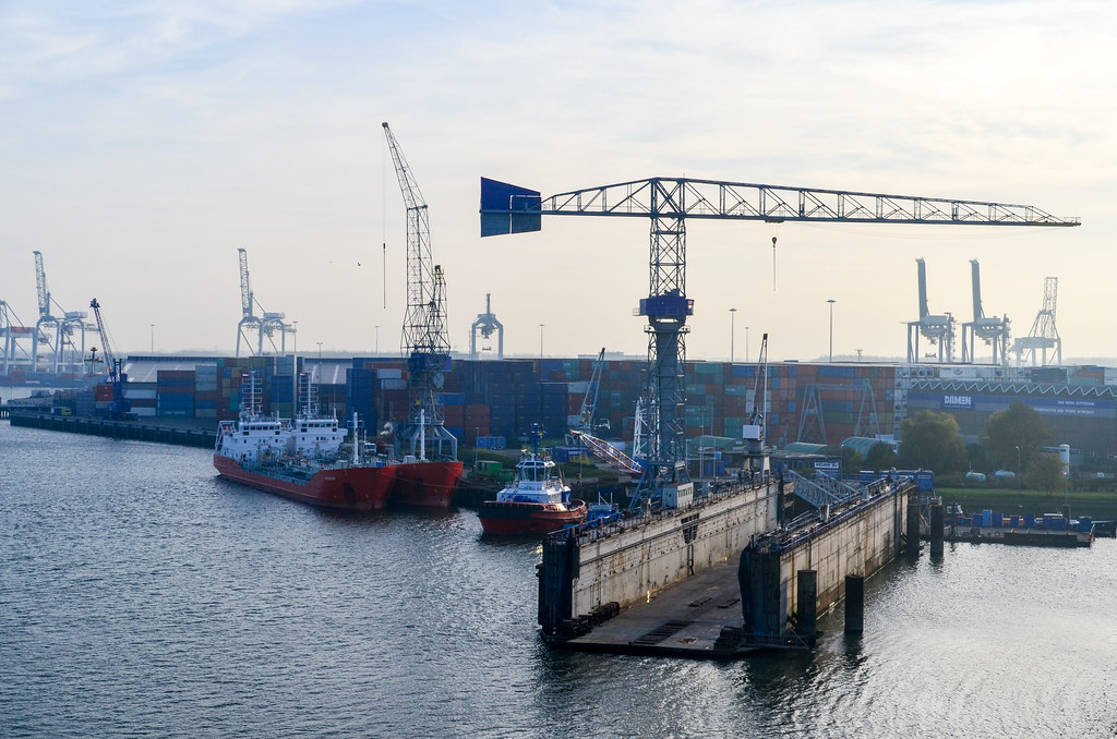
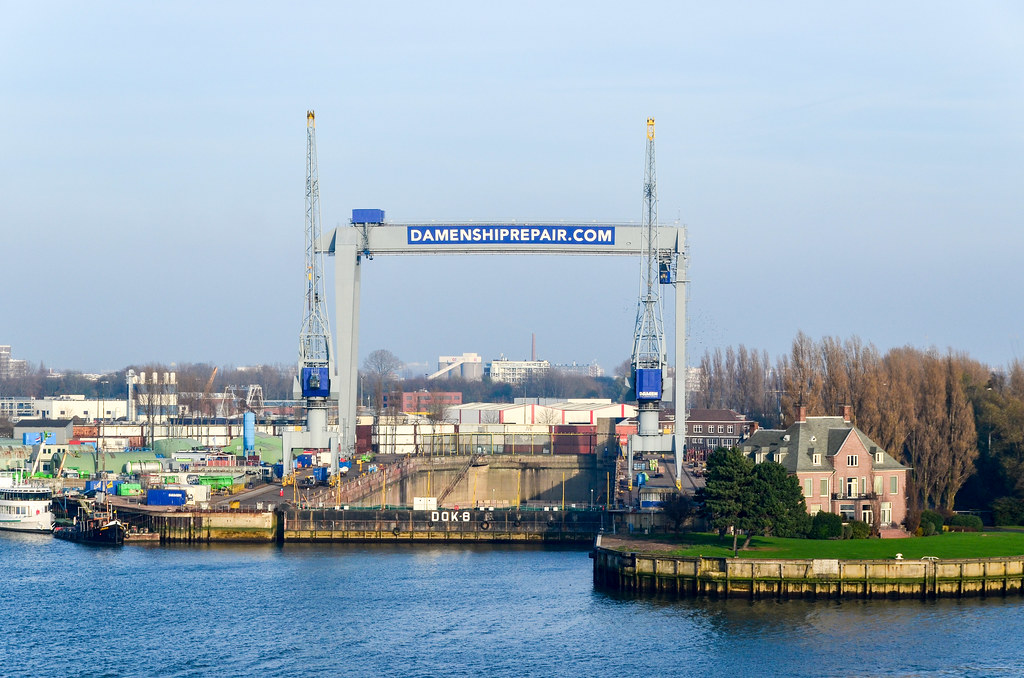
This one has several dry docks and the service center of Rolls Royce Marine.


Vessels can be a fun and original marketing support too. For example, I was told about the Borussia Dortmund vessel, named and painted after the German football club. And ironically, it is docked in Rotterdam right on the opposite berth!

The radars of any ship in the vicinity of that boat will display the vessel name on screen. And if the ship manages to dock in historical ports, where the city is built around (Cape Town, Hamburg) and not relocalized away (Rotterdam, Tangier Med), at berths with good visibility, these ships will surely be seen from the city center. Like a 5-storey building covered in advertising and moving from city center to city center.


At 4 pm, we finish parking at our berth in Beatrixhaven. It’s too cold! And the sun sets already. No way anyone can hide and sleep in the shade. If I step outside and don’t move, I’ll freeze.
I’ll be leaving the ship tomorrow morning, and spend the rest of this day preparing. In the meantime, cranes are emptying the entire ship.


Now docked, my first goal is to find wifi to announce my arrival. This port is the worst place for it … and I end up walking 3 km, eyes on my phone, until I can find unsecured wifi outside. In this area, there are roads bordered with piled up containers only, without a single house. Then it’s night, my fingers freeze and my battery dies. So much hardship just to send an email …
Back “home” in the ship, my bike preparation consists in pumping up my tires and swapping the mirror’s side. I adjust my brakes too. Schwalbe inner tubes were really great, I didn’t pump them at all between Switzerland and Mauritania. Now, with standard tubes, I have slightly deflated tires after 3 weeks of inactivity, which is normal.

After the containers have been removed, the real show can start. The sun sets but the cargo deck opens. I will finally see what’s hidden in the bowels of the ship. Instead of packing up in my cabin, I stay outside and watch the cranes unloading the break bulk.


In the meantime, a Figee Marcor 2 crane mounted on a barge floating next to us is getting ready. We open the tweendeck, and for the first time I see the very bottom of the ship. Twice deeper, it’s a hole of 18 meters deep under the main deck. The ship’s cranes are used to remove the tweendeck separators. Then the floating crane takes the cargo (minerals) from our lower deck into a floating barge on the other side: it’s an insane amount of power and steel at work right now! There are 10 cranes around the ship (6 on the ship, 3 from the port, and 1 on a barge), and things move into all directions. We carried some 25000 tons of stuff from South Africa and Namibia, and unload it now, 20 tons at a time. When the shovel hits the hull, my bed shakes.


This kind of barge can then travel within Europe. For example, via the Rhine, the cargo can travel straight to Basel without leaving the waterways.
Including the unloading operations, I compiled a video di tutto il viaggio su una nave:
The floating crane is still unloading cargo in the morning, but unloading my bike won’t be that easy: the small rear crane that the ship uses to put the gangway in place is not working. Instead, they have attached a large net under another crane, and they will be unloading some luggage with that solution. I thought leaving Africa would also free me from the usual “Sorry Sir, the <insert whatever here> is broken so we can’t <insert expectation here> …“. Not yet.


I am not keen on letting my bike mix with luggage in a loose net, but at the same moment, they inform me that they have just set up the side ladder and a gangway, steeper and less stable, but okay for my bike.

Here are my wheels touching European soil again, two years after leaving it. It’s kind of a special moment. My eyes are myopic again, suddenly. They can’t bear the cold. The first “local” I talk to is the lady at the gate of the port. She sees my South African flag, still attached on my bike, and says she’s from Vereeniging in Gauteng.
It’s incidentally my first time in the Netherlands and I don’t know how is Dutch different from Afrikaans. Apparently, it’s very different, since practicing my little knowledge of Afrikaans gets me weird looks.
I can’t bear the cold, but one good point is the presence, even in the port, of cycling tracks! From Africa to the Netherlands, from the urban jungle to the land of bicycle commuters.

The best is when cars stop at cycling lanes to yield the right of way to cyclists. Ha! Traffic lights, public bus service with digital time announcements at bus stations … Ha! I don’t even have to cycle on roads since cycling lanes take me all the way through Rotterdam. But the Dutch beat me at this game: it’s Sunday morning, I am freezing, considering taking a train, and all these people are happily cycling.


Even with the magic bike paths, it takes me ages to cross Rotterdam while trying to find free wifi in the streets. There are 50+ of them at all times, but all WPA. The buildings in the city center are covered with fog. It’s time to be realistic and to quit: I won’t be able to cycle to Amsterdam today. I overestimated my ability to deal with the distance and the cold. I can now take hours of sun on my skin without sunburning, but I’m unable to be outside by 3°C. I need my old skills back.

Luckily, civilization also comes with trains that work fine and plenty of space to board them with my bike and liters of luggage. And the best … free wifi! My day of cycling stops at Rotterdam Noord and I’m taking the train to Amsterdam and meeting with Arjan.
Travelling far abroad and for a significant time also make returning home a mini-counter-cultural-shock. I remember how was France after almost 3 years in Japan: “but why is nothing working here? Why are the shops and restaurants never open?” From my train window, all the houses are good looking, public transport seems perfectly integrated, bike paths mirror almost every road, industrial areas are everywhere but separated enough from the living areas … it really looks like an efficient and healthy lifestyle (despite all that flatness).
I get to see the town of Gouda (it’s not only a bad cheese) and the Ajax’s stadium. It’s also a good opportunity to learn how are Holland and the Netherlands not the same thing, and how they are not confusing at all once we dig into the geography of whole Kingdom of the Netherlands (lezione utile qui).

It’s time for me to upgrade my old N900 smartphone, faithful but obsolete without apps, to an Android model. I missed so much in 2 years, and would never have thought that one day half of the people would have a linux kernel in their pocket.
From Amsterdam, the freezing cold prevents me from cycling for a week until Eastern France. It’s as cold as when I left, but I can’t re-adapt to the cold, it’s strange. Luckily there are many train lines. From Amsterdam, I quickly dismiss the option of passing through Paris: very expensive trains, very bicycle-unfriendly, and rather cumbersome to commute with a loaded bicycle between Gare du Nord and Gare de Lyon. It seems better going through Germany with the DB: more trains, nicer website and schedules, and carriages equipped to transport bicycles. But, on second thought, travelling with a bicycle in DB trains require planning since a reservation is necessary. And it’s not cheaper than the SNCF. I risk being stranded in Cologne, and I’d rather not. My last option is the safest: Dutch and Swiss slow trains via Luxembourg.

Unlike the Android market share, what didn’t change in 2 years is the quality of service of the French trains: the SNCF is on strike, and since the SNCB-operated train to Basel passes on French rails, it is cancelled. I am forced to spend a day in the grand duchy, and it’s actually very pleasant. From the old town to the modern architecture of the European and finance institutions in Kirchberg, it is vale la pena visitare, at least for the irony of the EU being partly administered from a wealthy tax haven. There are no security guards or fences anywhere and I can even cycle through the European Court of Justice.

I cycle the last 100 km of my return journey from Basel to Pontarlier. It’s still as cold but I now feel ready. The Torre di Rochein Basel, which construction was about to start when I left Zürich, is now nearly finished.

Upon the advice of my WS host Joerg, I cycle to Saint-Ursanne via the Sundgau, Kiffis and Lucelle, on a route following the border. It’s very pretty, most of the roads are white since it snowed last night. It seems I’m “repaired” and I can cycle again in the 2°C fresh air. It’s also fun, as I cross the French-Swiss border 10 or 12 times. Remembering how painful and inefficient is an average border crossing in Africa, it’s really a pleasure to see all these old border posts closed and nobody checking IDs. At the end of the day, the Swiss mobile customs unit will eventually spot me and carry out a quick inspection.

A last stop in La Chaux-de-Fonds and last stretch of road in Switzerland, cycling in between factories of luxury watchmakers, and I’m back in France.


Fascinating. I found this by accident, and read every word. Thanks for all the info – it felt like I was really there. Now I’ll have to read your other articles as well!
I came on your story by accident and have been glued to my computer until I came to the end. I travelled many times on ships back and forth from Europe to SA in the 1950s & 60s, especially on a German cargo vessel from Durban to Barcelona in 1965. I have also crossed Africa overland in 1965 and 85. I was delighted with your excellent story and fine photos.
How much simpler all travel used to be and shipping freight was so much more efficient in those far-off days.
Thank you so much for your great effort to publish this story.