Mis compañeros de ciclismo-brandy-barbacoa se pegan a la carretera principal, la N7 hasta Nuwerus. Pero después de un gran día por Leliefontein ayer, no puedo evitar dejar Garies para la tierra otra vez. Vía Lutzville, debo ser capaz de llegar a la costa dentro de dos días.

Fincas mira mucho menos elegantes que en Namibia. También están más cercanos de la carretera de grava. ¿Parecen más numerosos, así que tal vez cada finca tiene un terreno más pequeño que en Namibia? Tendría sentido, desde la precipitación, aunque ridículo comparado con el este del país, es todavía mucho mejor que en el Namib.
Lo que me dijeron antes sobre los caminos de tierra parece estar verificando: Namibia tiene muy pocas carreteras de alquitrán, pero la vasta red de carreteras de grava casi siempre está en excelentes condiciones. Por otro lado, Sudáfrica tiene un montón de carreteras de alquitrán de alta calidad, pero sus caminos de grava no parecen tan mantenidos como en Namibia.


El camino no es tan interesante, y no hay nada realmente bonito. Mis varios mapas indican varias carreteras, y hay aún más caminos de tierra y pistas por ahí, es un poco confuso.
Además, la lluvia está empezando, hace frío y está húmeda, y no se siente como un día para estar afuera.

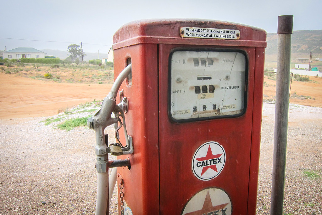
Kotzesrus es una pequeña aldea de personas que viven de actividades agrícolas. Me refugio bajo un techo que parece ser el punto central de la comunidad, con una tienda (cerrada), una antigua bomba de gasolina y anuncios sobre un estudio ambiental relacionado con nuevos proyectos mineros en la zona. Pregunto por los caminos a un hombre que pasa, y él me dice que el mar está a solo 15 km. ¿Qué pasa con todos estos caminos frente a mí y en mis mapas? Ah, son los mismos, pero uno va por donde vive la gente negra. Entonces es similar a mi encuentro con el enorme población de Aussenkehr que apenas estaba mapeado, o con esa ubicación detrás de una colina en Twyfelfontein, el único lugar para comprar espaguetis dentro de 50 o 70 km, pero muy bien escondidos. Definitivamente hay un problema con la asignación de algunas áreas, que parece dejado deliberadamente fuera de zona de conocimiento del viajero. Tal vez es el más pequeño de los problemas de personas que viven en municipios y asentamientos informales, pero desde todos los caminos y todas las tiendas posibles y punto de agua es importante para mí, me lo afecta mucho.
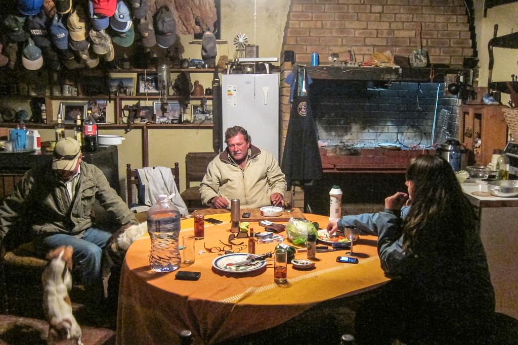
Since the rain is not stopping, I accept Etienne’s invitation for a tea in the guesthouse he is setting up. Before that, the lady running that small community shop arrives, and not only can I buy a cold Coke, I can also luckily take some of the droëwors freshly made from game meat her husband went hunting in Namibia. It’s 100 rands for 1 kg, and it’s always useful!
Las paradas de lluvia ya no ganas de permanecer aquí más tiempo, pero prefieren utilizar el poco tiempo queda de luz para desplazarse más lejos. Etienne llama a un amigo suyo que tiene una casa de apartamentos 16 km de distancia, en mi dirección, y en que tierra pude configurar mi tienda. Es una buena idea, ya que no es tan fácil de "sueño en cualquier lugar" donde cada pedacito de tierra pertenece a una granja.

Sé que comparo mucho a Namibia y Sudáfrica, un poco como comparé a los países de África Occidental. Namibia y Sudáfrica occidental están lo suficientemente cerca en términos de clima y densidad de población; Namibia fue administrada por la Sudáfrica del apartheid hasta 1990; la organización social, la economía (diamantes, minerales y carne deliciosa), la gente (khoisan y europea) tienen mucho en común, en una tierra que se extiende a lo largo de una distancia tan grande como Burdeos-Budapest, Barcelona-Copenhague o Monrovia-Lagos.
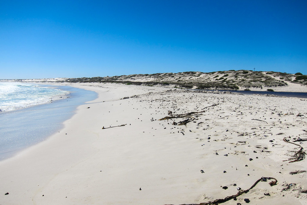
Puedo volver a ver el sol cuando se pone, y es mucho más agradable que una tierra gris y plana. Pero es casi de noche, y la lluvia ha hecho que el camino de arena/grava sea pegajoso.


Finalmente es de noche y todavía estoy en la carretera. Me dije a mí mismo que nunca debería terminar pedaleando solo por la noche en Sudáfrica, pero aquí estoy. Esa casa no debe estar muy lejos... hay una última gran bajada, durante la cual veo muchas luces muy, muy lejanas. Tal vez una ciudad para mañana. Ayudado con la lámpara de mi bicicleta y el faro, finalmente llego a esa puerta y puedo comenzar a inspeccionar los edificios. La casa de autoservicio está cerrada, el granero está completamente lleno de heno, pero encuentro un poco más lejos un cobertizo medio en ruinas ... ¡perfecto!

Perfecto… o casi perfecto, ya que un ave se coló y no puedo sacarla. Considerando los muchos excrementos de pájaros en el suelo, prefiero montar mi tienda de manera que evite despertarme con una sorpresa desagradable en el cabello.
¡Y duermo 12 horas seguidas! Realmente necesitaba una noche larga como esta después de andar en bicicleta con otros. Simplemente no es sostenible andar en bicicleta todos los días y salir de fiesta o charlar por las noches.
I continue on my road of rural Western Cape. I’m approaching Cape Town (my destination is only 5 days away), but it still looks like Namibia: relatively good gravel, no cars at all, and a few farms and windmills. Except it’s green and massively cloudy. The clouds only change the whole experience, I have been treated with so much blue sky for so long in Namibia that I forgot there could be days when my camera sensor is unhappy.


This railway is the Cape Town – Bitterfontein railway, used to carry ore from the Okiep minas de cobre, cerca de Springbok. No parecía que hubiera mucha actividad, pero el ferrocarril tiene vías “nuevas”. Me pregunto qué tipo de trenes circulan aquí y con qué frecuencia.
Estoy esperando para reunirse con elFerrocarril Sishen Saldanha, lo cual es muy emocionante (para mí), ya que el tren que circula allí es uno de el más largo del mundo. Es un tren de mineral de hierro, igual que el tren de SNIM de Mauritania que transporta mineral de hierro desde la mina de Zouerat/Fdérik, que He visto cerca del puerto de Nouadhibou. El ferrocarril Sishen-Saldanha debe estar cerca.


And suddenly, the tar reappears at a T-junction, with the Landplass station. A brand new tar road, still in the middle of nowhere. Trucks are coming from the east, on the coast, where a sign calls that place “Brand se Baai”, but I have nothing on my maps. It’s another “road paradox”, at the other end of the spectrum, balancing with the paradox of dirt roads leading to townships with a significant population. From my cycling experience, a nice tar road leading to nowhere, when there’s not so many tar roads around, is often linked to a mine.
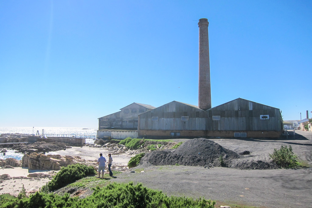
, mineral separation plant")
Y a unos kilómetros más … ¡Bingo! Una planta de separación para la mina Namakwa Sands, propiedad de Exxaro, en Brand-se-baai, al final de esa carretera asfaltada, que en realidad pareceEsto.
El nuevo asfalto significa que mis últimos 30 km hasta Lutzville serán rápidos. Lutzville es conocida por sus viñedos. El pueblo está ubicado en el Olifants river, y desde el vista de satélite, parece que todo el río se está utilizando para la agricultura.
Cinco kilómetros antes de llegar al pueblo, Amanda me llama. Es la ciclista de la que Etienne me habló ayer, y nos habíamos intercambiado los números de teléfono. Ella dice que se está quedando en una granja cerca de Lutzville, y que debería llegar allí. Ya estoy en los viñedos, pero necesitaría algo de tiempo para completar los 10 kilómetros restantes.
Sin embargo, mientras paso por la fábrica de tomates, un pick-up se detiene al otro lado de la carretera, y me dicen que suba. ¿Qué? ¿Cargar mi bicicleta y conducir? De ninguna manera, eso es hacer trampa, y estoy decidido a andar en bicicleta cada poco. Es extraño, en realidad, cuanto más progreso en mi viaje, y más me radicalizaré para hacer todo por mi cuenta. He tenido que hacer trampa cuatro veces hasta ahora, siempre en contra de mi propia voluntad, pero seguramente pedaleé unos cuantos miles de kilómetros adicionales para compensar las pocas docenas que mi moto no podía hacer. Amanda llama de nuevo, más o menos pidiéndome que no sea tan estúpida cuando envió a Jasper sólo por mí, y eso hace que mi 5a y última vez haga trampa para todo el viaje.
Estoy un poco molesto hasta que lleguemos a la granja de Jasper. No es realmente elegante, no hay agua corriente hasta algún momento en que fluye amarillo, pero mejor que el agua, ¡hay brandy y carne! "Estas son las mejores chuletas que se pueden degustar en Sudáfrica", dijo, y rápidamente resulta cierto. Bueno, cuando me tratan con un braai después de un día en la carretera, creo que tiendo a estar de acuerdo con bastante facilidad. Amanda es más o menos vivir en su bicicleta, por lo que también es muy fácil de conectar.
La hospitalidad afrikaner que he estado recibiendo hasta ahora en Sudáfrica es un poco increíble, como resultado no he dormido realmente fuera. Y siempre viene con un braai y carne hasta que se llena, que es básicamente lo que he estado soñando durante el último año. Algo sorprendente es que siempre he sido recibido por los blancos. ¿Dónde están los negros? De hecho, las negras (como en Bantu) la gente nunca ha vivido en la mitad occidental seca de Sudáfrica. Fue el hogar de la Khoisanhasta que los europeos se establecieron en Ciudad del Cabo, y progresivamente se apoderaron de la tierra. Hoy en día, el mapa de población dominante of South Africa still shows clearly the division, and that’s why I don’t see as many Black people as one could expect for Sub-Saharan Africa. The map defines the dominant population of the Northern Cape and the Western Cape as “Coloured”, as were called, during the apartheid, people not white enough, and not black enough (and also, not Indian)(so it leaves the Khoisan themselves, and the people resulting from natural mixing and re-mixing between the Khoikhoi, the Europeans, and the imported slaves)(if it doesn’t make sense, it’s normal).
By the way, anywhere in rural areas between Senegal and Angola, I would be called “White White White!” up to a hundred times a day, and possibly asked for a present, but after explaining that I am not a journalist and am just looking for food and water, it’s often that I ended up sharing a meal and offered a place to stay. In rural South Africa, nobody is calling me White or trying to get my attention, I guess because my whiteness is no more special, and possibly because whiteness is more associated with apartheid than with tourism or with Santa Claus. The only ones hosting me are the ones whiter than me. Amanda says that I’d have to cycle the Eastern Cape, to find a positive experience similar to the ones I had elsewhere in Africa.

Si lo entendí bien, Jasper es el mayor productor de batata del país. La zona agrícola no es más grande que la granja promedio en Namibia, pero probablemente es más fácil de trabajar y parece producir mucho más. El problema es que no puede hacer planes a largo plazo, ya que tarde o temprano su tierra será confiscada y redistribuido. De hecho, Sudáfrica y la desigualdad son casi sinónimos.
Mi país anterior, Namibia, es el país donde la proporción de los ingresos medios del 10% más rico al 10% más pobre es la más alta del mundo. Sudáfrica casi está encabezando la lista mundial de países clasificados por índice Gini, que es una medida propuesta de desigualdad de ingresos o riqueza. La función matemática detrás del índice de Gini es demasiado simple para considerar la historia, la diversidad de la población y el crecimiento de los países estudiados, pero funciona bastante bien para quien se pregunta ¿Dónde está el lugar más barato contratar a mi prójimo como a mi empleada doméstica“.
Estos dos, junto con Angola, Zambia y Botswana, están en los 10 peores Gini del mundo (el caso de Zimbabue no cabe en la fórmula), mientras que los escandinavos están, como de costumbre, en el otro extremo del espectro. Así que parece que los africanos del sur tienen un problema con compartir. Cabe señalar, también, que la independencia en el sur de África se obtuvo un poco más tarde que en el resto del continente.
Volviendo a la agricultura ahora. La propiedad de la tierra es una de las representaciones más obvias de la desigualdad en Sudáfrica, y una legado del apartheidTodavía hoy, los sudafricanos blancos, que representan el 9% de la población, poseen mucho más del 9% de la tierra. En realidad, es difícil obtener los números reales, tanto como es difícil encontrar honestidad científica en lo que respecta a asuntos políticos. Actualmente, el gobierno está tomando tierras de los agricultores blancos con compensación y entregándolas a comunidades administradas por negros. Parece algo bueno en comparación con ¿Qué Zimbabwe, pero naturalmente no hace felices a los agricultores blancos. Entre las cosas más amables que he oído sobre los sudafricanos negros están , cuando reciben una granja gratis, comprarían un buen coche en lugar de invertir en herramientas y hacer planes, y eventualmente la arruinarían", o"usan bienestar para vivir de forma gratuita a los contribuyentes unos. Verificado, es cierto que solo el 6% de la población sudafricana paga impuestos (en comparación con el 51% en EE. UU. o el 46% en el Reino Unido). También es difícil pagar impuestos cuando simplemente no tienes dinero.
Parece que todo es, y tiene que ser, acerca de la raza. En comentarios más ligeros,los verdaderos rednecks son los británicos; un afrikáner no se quema al sol, sabe cómo lidiar con África", o"cuando hace demasiado frío en el Estado Libre, el afrikáner se pone dos pares de pantalones cortos. Los blancos sudafricanos se pueden 'dividir' en dos subgrupos, losAfrikaners(como Charlize Theron), en su mayoría de origen holandés, con algunos hugonotes franceses también en los barcos, quienes se establecieron por primera vez en 1652, y losBritánico(como la Princesa de Mónaco), en su expansión colonial, que se unieron a la invasión unos 150 años después. Por supuesto, lograron luchar entre ellos, incluso tan al sur.
También escucho mucho acerca de lo perezosos que son los sudafricanos y de lo trabajadores que son los zimbabuenses. Por otro lado, estos mismos zimbabuenses son los primeros a quienes se acusa cuando se reporta un crimen. Me recuerda que tendría que ir en bicicleta por allí, aparentemente a Botsuana por la vida silvestre y la carne más barata, y a Zimbabue por su gente acogedora. Podría haber girado al este desde Namibia, pero ya quería terminar y fui directamente hacia el sur.
Despite the apparent technological predisposition of South Africa (the first human control of fire, the first heart transplantation, Ubuntu-Linux, plans for the futureTelescopio de radio SKA, and Elon Musk were made there), the richest men of the country are mostly into mining, and the top politicians are super rich and super corrupt. My takeaway is that, even if it’s hard to define South Africa as a first world or a third world country (it’s nowhere near as undeveloped as what I have seen further to the north), it has for sure both first world problems and third world problems. Besides that, the landscape is beautiful.
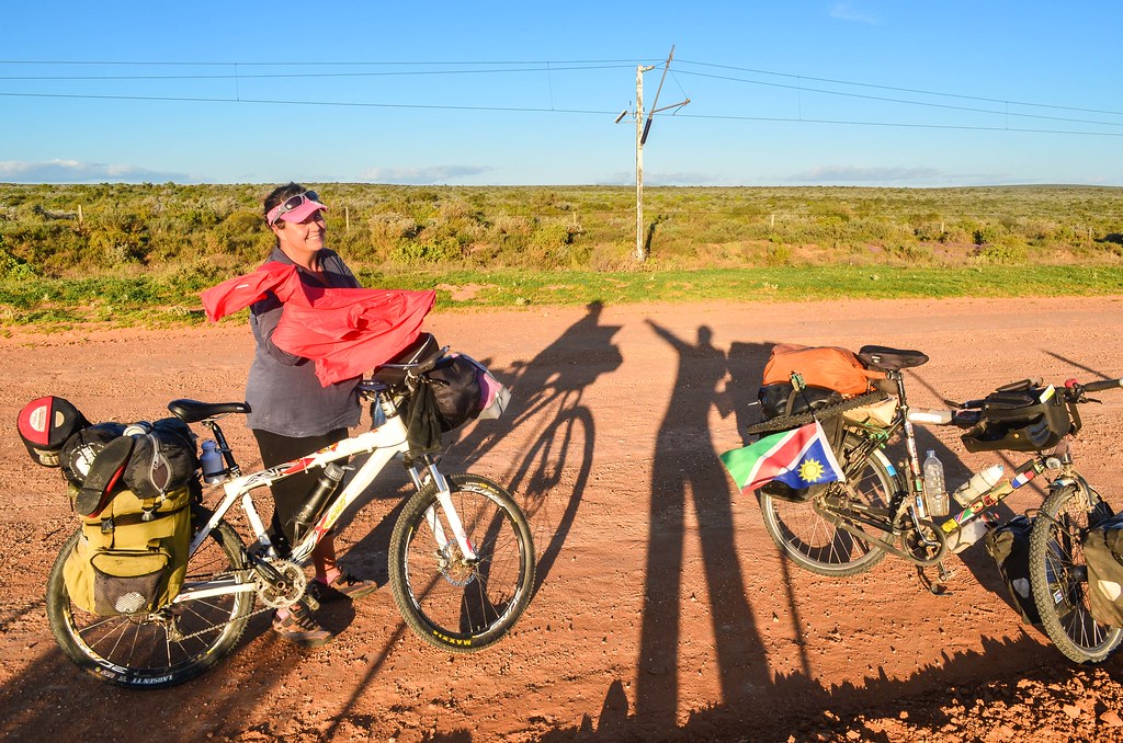
Partimos al día siguiente con Amanda, rumbo a la costa en dirección a Ciudad del Cabo. Ella ha recorrido la zona en bicicleta muchas veces, así que sabe mucho sobre los lugares que ver.

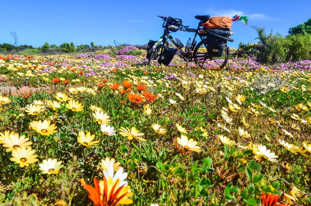
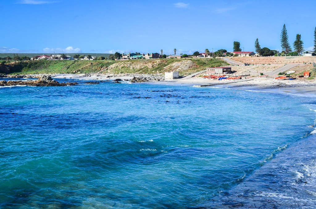
¡Tadam, el mar! Logré evitarlo durante todo el viaje. Ahora estamos juntos hasta el final. La desembocadura del río Olifants está justo allí, con un parque eólico al fondo. Se llama Papendorp. ¿Quizás vea más flores del Cabo a partir de ahora?
(Papendorp), Sudáfrica")
Amanda sugiere que podríamos entrar en el primer pueblo costero de nuestro camino, Strandfontein. Parece una elegante casa de vacaciones junto al Océano Atlántico. Sin embargo, tendríamos que bajar y volver a subir en bicicleta ... Estaba listo para eso hasta que dijo que uno de los próximos pueblos tiene mariscos y una finca vinícola. No es carne, pero aún así me queda bien.


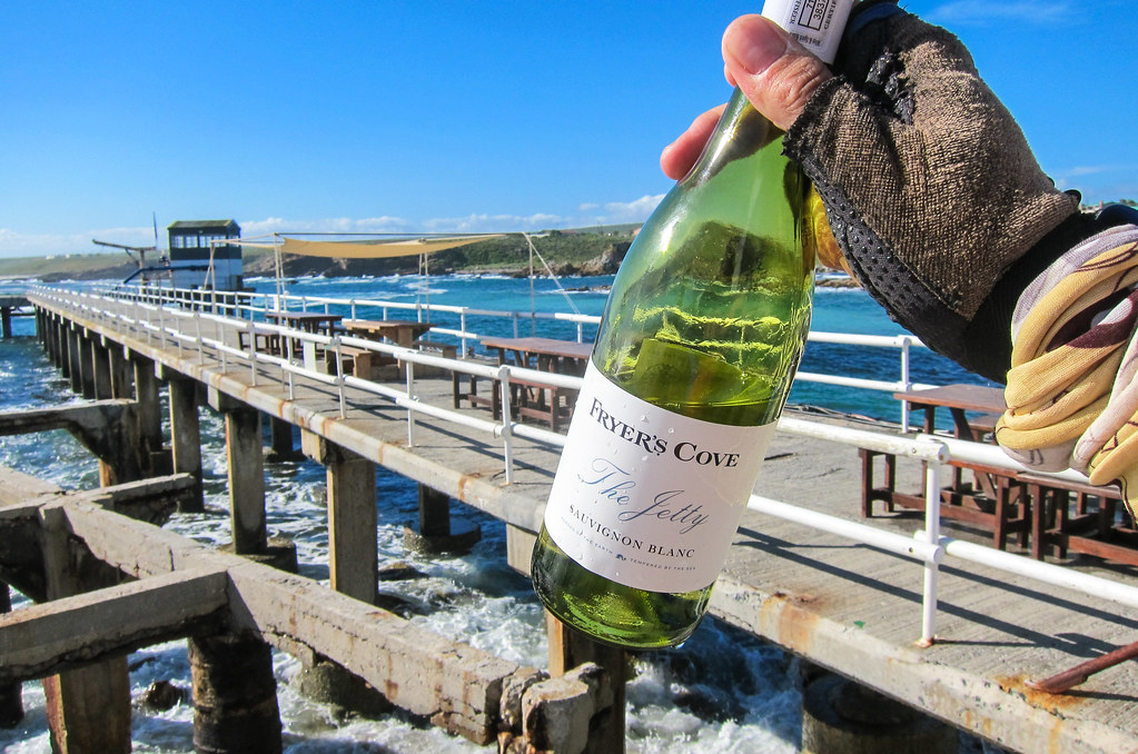
Mientras poso en las flores, ¡veo una ballena! ¡Justo ahí! Está siendo un muy buen día, y lo mejor aún está por venir. Alcanzamos Doringbaai, another coastal village, just after passing a vineyard on our left. It’s a tiny estate, and they don’t sell their wine in many places, but it’s possible to taste it at the restaurant on the pier, near the old crayfish factory. And we end up buying a bottle with our seafood.

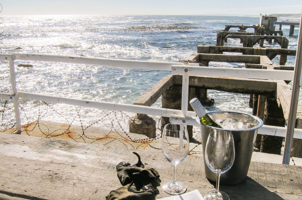
It feels strange, since my fanciest lunches on the road have been a plate of rice or some cassava-based meal. And today, we just need to stop with the same bike, same dirty gloves, and we can have real good food in a superb setting? Then why have I been touring Africa? Why did I do that to myself? That’s my initial reaction … but I know well that comfort quickly gets boring, and adventure is not found at the bottom of a wine bottle.
Our target for the day was Lambert’s Bay, the largest town on the coast, where Amanda has friends. But it’s 16:30, and we only cycled half the distance from Lutzville. Hmmm … not really smart, but not guilty either, since the stop in Doringbaai was worth it. Despite a bottle of wine in the legs, we decide to stick to the plan and see if we can reach Lambert’s Bay before night.
")
The 34 kilometers between Doringbaai and Lambert’s Bay are easily feasible, even if the map show the road R362 cut between the two places. The tar road is indeed stopping, but we can easily continue with the Transnet private road. It’s a dirt road always sticking close to the iron ore railway line, originally a service road, but now open to anyone. It allows to cut through nature reserves.
")
")
And finally, at the end of the day, the giant caterpillar shows up on the railway. The Sishen-Saldanha train once held the record of the longest train in the world, with 16 locomotives, 660 wagons and 7.3 km in length. It’s like if one train has wagons continuously filling up the rail track between Zürich HB and Schlieren. The only way to see it entirely is ir en el cielo. It runs 861 km from the Sishen/Kathu iron ore mine in the center of the country, to the port of Saldanha.


Este tren, que tomo en su camino de regreso desde Saldanha, es uno regular: solo 8 locomotoras, 342 vagones, con una longitud de 3.780 metros. Es lo suficientemente largo como para probar todos los ajustes posibles en la dSLR. Pasaré por Saldanha más tarde para revisarlo en la terminal.
Ahora, todavía quedan 15 km para recorrer en bicicleta de noche. Afortunadamente, el camino de servicio es muy tranquilo, y tenemos dos potentes luces de bicicleta. Aun así, decido ponerme mi chaqueta reflectante antes de entrar en Lambert's Bay. Es viernes por la noche y el pueblo es la ciudad costera más grande de la zona, con la impresionante cifra de 6000 personas.


That Transnet service road has gates from time to time. Despite being open and free, it’s still a private road and cars are being checked. But it’s really the best way to cycle north or south in Western Cape.
With little visibility, we finally reach the town where Karen and Marais, Amanda’s friends, welcome us, directly at the bar. Straight from night to light, and from peddling to drinking. We’re not dirty enough to need a a shower right away. Some of the music playing sounds like something I know … It’s old Afrikaans songs, but … do I really know it? It sounds exactly like Apres-Ski music! I was already finding Afrikaans and Swiss-German quite similar in how unsexy it can sound, and now I can’t help thinking about Esto.

Marais is here a first name. As a last name, Wikipedia las listas más Marais in South Africa than in France. Without forgetting all the wrong things that White settlers have done to the people here, I find it interesting to notice some European heritage at the bottom of the world. Amanda will stay longer in Lambert’s Bay to delay her arrival in Cape Town where she doesn’t have a house yet, but I will get on the saddle tomorrow. I’m only 3 days away from my destination!


Contesta