I have barely seen any greenery in a long time, actually since I left Ovamboland in the north. Namibia has only two perennial rivers, the Cunene and the Orange, and these two are not even really inside the country, since they are defining the borders, respectively with Angola and South Africa. I could also mention the Okavango, the Zambezi and the Chobe in the far east, in the Caprivi strip, but they barely contribute to the main land.
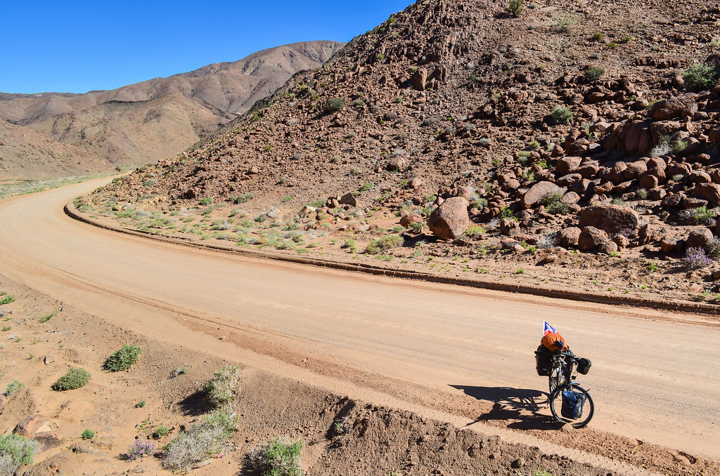
After more than 3000 KM in stones and sand around the Namib, I am now less than 50 km from the Orange river and South Africa, and that’s when grass and bush reappear on the top of hills.

The too-much-sand on my Namibian pictures is also because I crossed Namibia during winter, between March and August. It must look less desertic in other months.
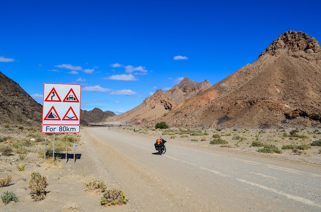
There is maybe one or two farms inhabited between Aus and Rosh Pinah, but I have seen no one for the last 130 km. I have another 30 km to complete until the mining town where I have an “appointment” to go underground. The clouds slowly break up and let appear a scenery totally different from the desert, but no less fantastic.


These are the Namasberge, or Namuskluft, mountain range. The popular attraction of the Fish River Canyon is “just” behind them. The wind is against me and it gets much colder as I go down. From 1000 m high, the 15 km long slope takes me to 400 m.


And that’s only the beginning of my sub-journey into a world made of Windows XP desktop wallpapers.
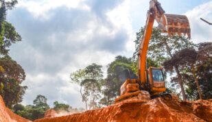
As often in Namibia, fantastic scenery goes hand in hand with mining activities. On the other side of the road is found the Skorpion mine, the 8th largest zinc mine in the world. It is exploited by Vedanta, a large Indian metal mining company. The mines lies after an airstrip some 5 km west, but there is already a security post right on the C13.


Rosh Pinah exists only for the mines. The town is as usual is clearly divided between the township ($30 a month to rent a shack) and the town center with the shops and the nice houses. The two are separated by the C13 road and the industrial activities of the Rosh Pinah mine, another zinc mine, this time not open pit, but right under the town. “Rural Southern Africa” + “mining town” are two ingredients that makes things very much apartheid-looking.
Ian from Lüderitz had contacted for me the mine surveyor’s department and arranged a visit underground, about which I am very excited. Seeing stones underground will feel fresh after seeing too many above ground. Unfortunately, they are busy today and will receive me tomorrow. It’s only lunch time and I’m already in the mode “eat + find a place to sleep”.
For a tiny town of 3000, Rosh Pinah has actually a fantastic infrastructure: a mini mall, a Spar and a Shoprite, a nice stadium and plenty of green areas, and 3.5G on the phone! I think I’ve read that Rosh Pinah was privately owned until recently, just like the most famous mining town of the country, the mysterious Oranjemund. Despite the many businesses, it’s deserted during lunch time and there’s just a few people roaming there. I have a Wimpy burger, Wimpy like in “the junk food I am thinking of when I eat spaghetti five times in a row”, but seriously turning into “Wimpy the tiny burger more expensive and more disappointing as time passes”.

Because I need to be early at the mine tomorrow, I can’t stay at the only campsite of the area, 15 km away in the hills. I roam around town to find a cheap guesthouse, but they’re all in the range of 70 € / night. That’s 10 times what I’m ready to spend for a night. From the excitement of entering a town full of shops, I am quickly brought down to earth and to the reality of cities: it’s not friendly, it’s not the bush and I can’t sleep wherever I want (it may seem obvious, but the population density of the country conditioned me to think I can sleep anywhere). Plus, Rosh Pinah is not at all a town for travelers, it’s 100% mining. Therefore, no campsite, no self catering, no caravan park, only business hotels and lodges.
I spend a good time cycling around town and asking every hotel where to sleep for cheap. Ahhhh I hate such towns, they are not nice places for bums. So far in Namibia, I have been mostly staying in the bush, at remote campsites or in town when I knew someone, so I didn’t feel that “unaccepted” in a long time. I have seen the township, bungalows probably for white collars, and now at the extreme south of town, maybe for the mine managers, houses look really nice, with pools, outdoor toys for the kids, shiny green grass. Well, it looks nice in the desert, but is still too close to American tract housing to look like somewhere where life is enjoyed.
I could actually sleep anywhere around the town: it’s flat, dry and unfenced. However, one hotel receptionist warns me about the many snakes and scorpions, and bandits, so, hmmmm. And it’s true that all houses being protected with private armed response (ah! welcome soon to South Africa!) and electric fencing doesn’t contribute to my peace of mind.
I finally receive the advice that will change everything: “if you find nothing, check at Lorentia’s“. Lorentia’s is a restaurant right in the middle of town, with a large garden. The lady offers me a deal: “I let you camp in the garden, but you have to eat breakfast here“. It’s the perfect deal for me, since for the price of a campsite, I get a buffet breakfast, a hot shower, and a central location.

And I just got a good idea to kill time during the afternoon: replacing my chain. Two days ago, I have thoroughly cleaned it, from every single sand grain, oiled it, and it’s squeaking already. It’s not every day in Africa that I’m camping next to a mechanical and outdoor equipment supermarket, so I’m taking advantage of the Cymot next door (this overlooked town has everything!) and get a chain for N$ 54. I know my chainring has lost a fair amount of metal over 25000 km, but instead of changing it (it’s very unlikely I find the right one), I’m just changing the chain. The previous one (from Cymot in Tsumeb) gained half a link (0,5%) in 2500 km. It’s not too bad, for a quarter of the price of expensive chains (my first one elongated 1% in 10000 km), and for someone who finds having a perfect noiseless transmission priceless.
During the evening, the ground shakes like during an earthquake. They are blasting in the mine, which must then be not too far from just below the town.

The mine surveyors manage to free time to take me underground. The mine’s surface is at 410 m above sea level, and it goes as deep as – 90 m. With 600ish employees, it has been operating for 30 years, and has 10 more years to go. But another new mine will open 10 km away.
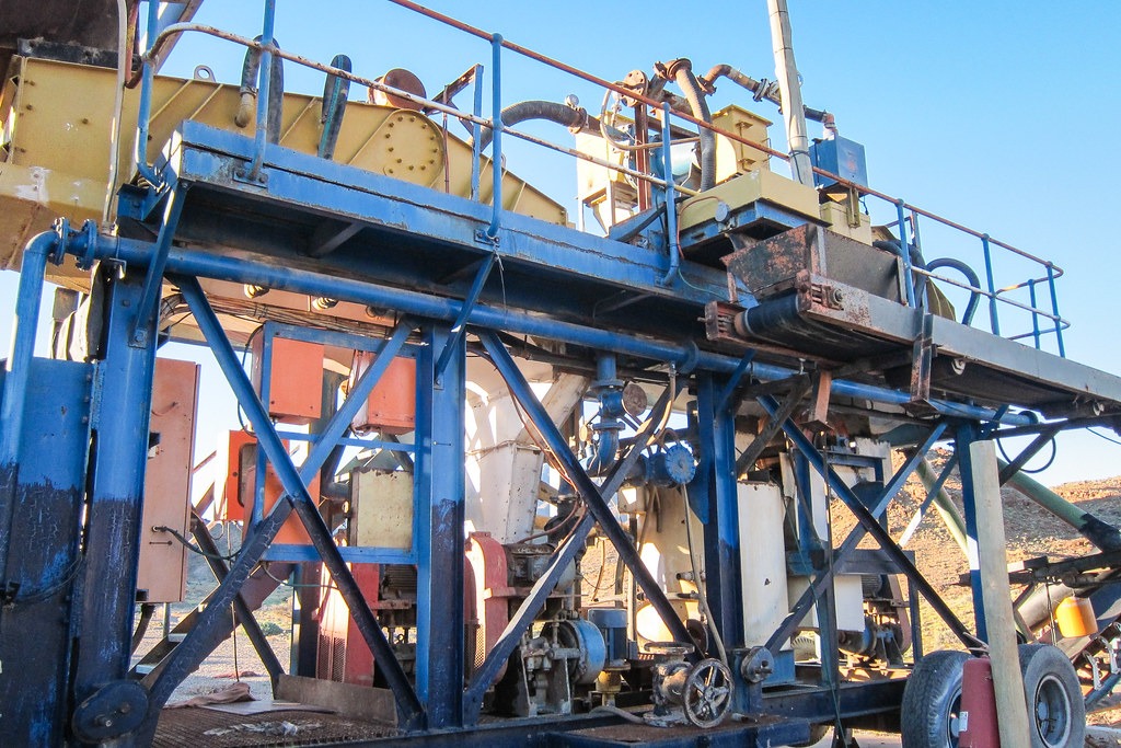
We drive a Toyota Land Cruiser in the galleries around the ore. The mining is done by stoping, i.e. blasting from the bottom between levels and creating a cave. The zinc and lead extracted by 30T haul trucks and concentrated to approx. 60% purity. I can’t take pictures inside the site, but I get to see how the 3D model and all the layers work. Every building of the town at the surface is also mapped.
I conclude my visit before noon and leave for the Orange river. I’m excited at seeing a new country. I won’t be crossing the border today (I still need a new passport) but after enough months spent in Namibia, I can almost forget that I’m supposed to be travelling a continent, not a county.
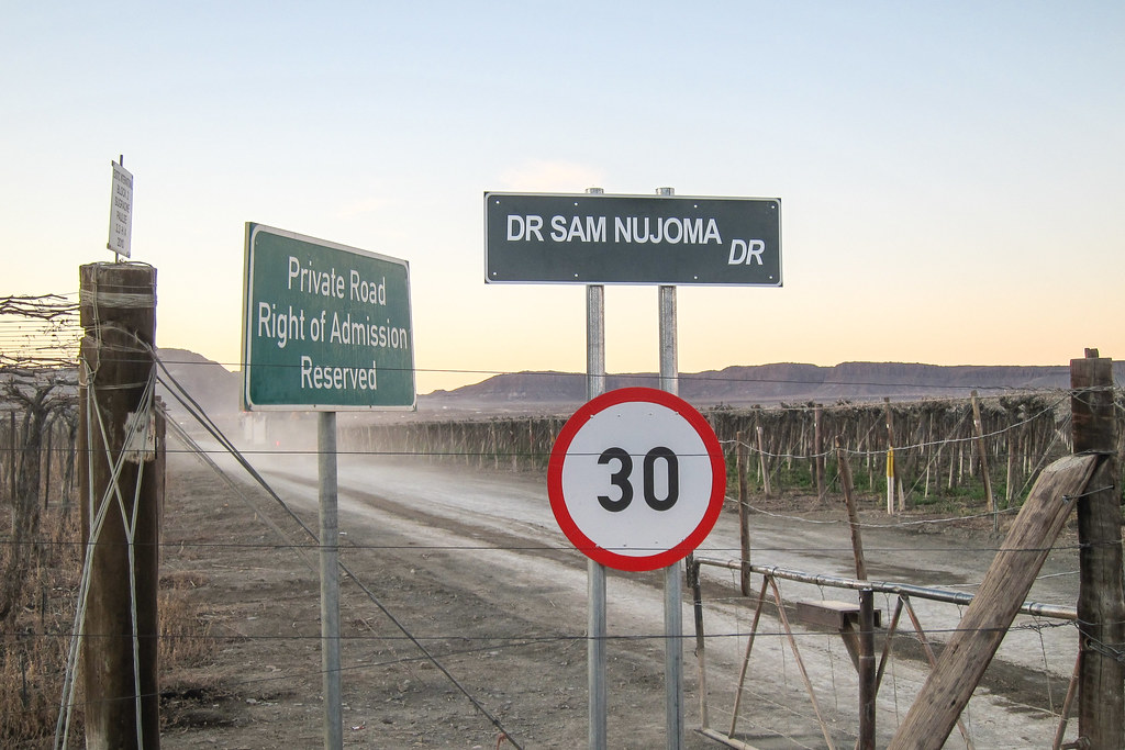
Shortly after Rosh Pinah is the turn-off to Oranjemund. That strange Namdeb/De Beers town was not part of the government until 2012, it used to be private diamond mining town, and even the second largest town of the country in the old times. The access today is still restricted to Namdeb workers (and potentially to visitors who apply 21 days in advance), even if the road from Rosh Pinah is now public.

A 1998 article from the NYT, entitled “Oranjemund Journal; Find a Diamond in the Sand? Just Don’t Pick It Up” was talking about how difficult it is to open an area, where diamonds are just found on the floor, to the public. Today, open, there is still a cave-at to use this road: it is controlled, drivers are forbidden to stop their engine, and I heard they time visitors between the two checkpoints, probably to make sure nobody accidentally finds a diamond and has one more proof that diamonds are priceless stones.
I wonder how they would react if I showed up at the first checkpoint and said I plan to use that road to cross to South Africa, but unable to go faster than 20 km/h and possibly sleeping on the road. However, I can’t see the first checkpoint from the C13, and I guess they’d not allow me anyway, so I don’t try it. I’d still like to visit one day, for the mysteries evoked in the documentary I talked about here, and for the graveyard of the so-called largest private earthmoving fleet in the world. These old impressive pictures were taken where the satellite imagery still shows them. It’s logical, as long as one abide by the mining mentality: quoting the NYT, “to prevent anyone from slipping diamonds into gas tanks or truck frames, no piece of equipment that enters the mine ever leaves. The company’s earth-moving fleet was once second only to the United States Army’s, and executives used to proudly show off the vast parking lot where every digging machine and truck used since the 1920’s sits rusting. Now, sensitive to its environmental image, the company refuses to let the vehicles be photographed. ”They’ll probably be melted down someday,” said Dries Olivier, a mine manager.”
Oranjemund is connected to South Africa via the Oppenheimer bridge. Who else could have given his name to a bridge between the historical commercial diamond mining country and the Sperrgebiet?
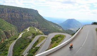
Anyway, I’m on another road. The C13 suddenly leaves the grasslands to enter another terrific canyon-like landscape during my last few kilometers to Sendelingsdrift.


It’s once again superb.

Sendelingsdfrift is a pontoon crossing between Namibia and South Africa. I am not crossing here since I first need my new passport: my current one doesn’t have the two blank pages required to enter South Africa. The plan is to cycle to Aussenkehr on that fabulous road, leave my bicycle there, make a return trip to Windhoek to fetch my new passport, and cross to South Africa at Noordoewer (they managed to spell it wrong on the road sign), which is the main border port between the two countries.

And that road is indeed amazing! I prefer it to the D707.


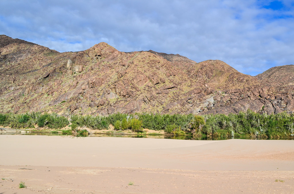
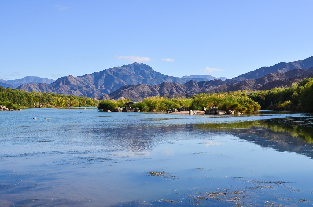
It’s not my first time seeing the Orange river: this river rises in Lesotho and runs 2200 km across South Africa until Oranjemund/Alexander Bay, I had seen it at the Augrabies falls in the green Kalahari. But it’s the first time seeing a river and so much water since March, 5 months ago, at the Kunene river.

The other side of the river belongs to South Africa. It’s the Richtersveld National Park, and it’s weird for a national park to have so many mines, like that one just behind the dike. From Google Earth, one can spot mining activities in South Africa, along the Orange river, every time there is a small piece of flat land allowing it. On the Namibian side, the national park mirroring Richtersveld is called Ai-Ais.


I feel tiny in between these sharp mountains of various brown colors. The gravel road is super nice and yellow flowers are moving with the wind. Is it spring? Plus, my new chain (the 5th one) runs smoothly over my old chainring and it’s a real pleasure to cycle here. This day could be an arctic one and last forever, I would still be cycling.
Despite being in a national park, I still encounter some mining equipment from time to time. What’s the point of calling it a national park if excavators are abandoned right by the road? Maybe they can’t resist finding diamonds, it’s the Orange river after all. It passes through Kimberley in South Africa, that same town which yielded so many mines and diamonds, and even the anti-blood-diamond process. Its mouth Oranjemund is also a diamond mine. Thus, alluvial diamonds must be found all over its shores.
Someone had told me earlier that old boundary stones still reading “South-West Africa” can be found along the C13, so I was glad to find one of these 25 year old artifacts. But it was not even for it, but more mining: “Mining area Kiwissi”, a name that even the Internet doesn’t know.
 mining equipment, southern Namibia")

Since there is no one on that road, I can explore the old dumps and try to find something interesting.
 mining equipment, southern Namibia")


My day ends when I meet a guard on the road. Here? There are two or three rudimentary bungalows. During the day, my first question (almost) to people on a lonely road would be “Do you have water? Can I eat this?“, but in the evening, it is replaced by “Where do you stay? Can I sleep there?“. Here, I can’t stay, because they are mining guys. Again … diamonds are all over. On the other side of the road, I just have time to snap the following photo before the boss arrives in a bakkie. I’d better hide for the night, if diamonds miners are all over and don’t appreciate cycling visitors …

The worst would not be searched and X-ray’d, but having to unpack all my luggage for inspection. With five bags on my bicycle, it could look that I am smuggling lots of stuff. The only people who have searched me have been the Gambian customs (for drugs) and the Ivorian ones (for bribes). Sadly I’m not smuggling anything into Africa, not even saucisson nor Swiss democracy.
Just after dusk, I find myself a nice spot by the river, in between trees (yes, real trees. I’ve not seen many in Namibia), where the ground is already partly covered by concrete slabs. Interesting … I’d say it’s either an abandoned mining base camp, or an abandoned campsite. I’d go for the mining base camp because of the concrete car inspection pit.
At night, there are so many different sounds! Many birds and frogs. The water changes everything. I hope there’s no crocodiles and that nothing climbs up the river to my tent … I’m almost at sea level and spring is here, so it’s much warmer, but apparently the Orange water is never warm enough to host crocodiles.
I skip dinner to watch the surroundings with the moonshine and listen to all the neighboring sounds until I’m sure there’s nothing bigger than me around … but quickly fall asleep. For 12 hours, twelve deserved (as every day) hours.

Having had a late lunch yesterday, and nothing to do in the evening, I fell asleep at 7 pm. So this morning is a good time to explore around and walk along the Orange river beach. It would make a perfect summer camp here.


Apart from regular gravel heaps on my left side, the road is terrifically beautiful.


The hills, shaped like pyramids, become too steep to allow the road to follow the Orange, and I am redirected “inland”, up to 450 m, and spend most of the slope pushing it uphill. On the South African side, the terrain is even more rugged, rendering such a longitudinal road impossible.
It’s a tough one but 200% worth it. I must have seen four cars today, one of them during this steep slope and it struggled to make it to the top. I can always push my bike, but heavy loaded or 2WD vehicles may struggle.


I can’t help taking pictures. The moon is there too. The satellite view is as impressive as the ground view.


I finally get to Aussenkehr and am treated with a surprising view: vineyards. Apart from a few bushes around the river, one wouldn’t think that something can grow here … yet Aussenkehr is a huge grape factory. I don’t know if I can call it a vineyard, because these grapes are sold as is. There are indeed wine producers by the Orange river, but way more inland in South Africa.


I knew very little about that place before: there is a Spar, grape plantation, and my CS host. But when I looked at maps, it didn’t seem like a town, but rather a small farming complex. I didn’t understand how can a Spar end up in such a tiny place. I didn’t have a satellite picture; paper maps omitted the place, and my GPS showed a simple place name equivalent to hamlet of 20, and no path other than the main C13 road.
Therefore I can’t believe what I see: a huge number of huts made of straw. It feels like a discovery: I expected a hamlet and a farm, but I face now thousands of houses and an immense cultivated land. Here again, a satellite picture speaks better: between the north of the Windows Phone 8 tiles and the C13, zooming a little bit, we can see how informal and numberless is the settlement. Life in houses made of corrugated iron sheets seems fancy compared to what is happening here.
Well, now the presence of a Spar and a liquor store is obvious. My CS host is a professional farmer, hired at the plantation as a manager, and he lives on the other side. I get his instructions wrong, don’t take the right road, and end up crossing the whole township. Absent from maps, but bustling with activity! Arriving at the end of the road, I have to enter the plantations and cross them until the bottom. The gate guards are waiting for authorization by walkie-talkie, so I can ask plenty of questions. Most of the people here, up to 30’000 (yes, bigger than Tsumeb) in the high season, from September, are from Ovamboland (2 days to the north by car) and they just come here to work in the fields. Nobody really lives here, and they build what looks more like a hut than a house just for the duration of work.
As I cycle the straight lines separating the grape vines, I am greeted by large trucks packed with people. It doesn’t look like an advanced way of managing labor … Some of them are stopped by the guards for having collected firewood while it is not the right day, and have to drop it. The next guards are already expecting a man on a bicycle, and they all know where I’m going. How so? I don’t know yet that Antonie oversees most of the vines of the area, so naturally everybody knows him.

The managers live in houses on the other side of the plantation, close to the river. Antonie welcomes me with delicious meat and braaibroodjies, a perfect dinner for a perfect day. While discussing, I learn that these plantations are only possible thanks to the Orange river nearby, and would still be sand and stones without water management. They need a lot of care to be ready on time, because the selling window is very short: these grapes are not cheap to produce, and can be sold, for the most part to Europe, only after the northern hemisphere ones are gone, and before South Africa starts producing theirs. So basically, if one buys expensive grapes in Europe in November, it could be from Aussenkehr.
Aussenkehr also makes a good place to leave bicycle and luggage, and hop to Windhoek to fetch my new passport. “Hop” is a short word to express the coverage of 850 KM, almost half of the country. Cycling the dirt roads and detours from Windhoek to Aussenkehr just took me 25 days. There are Intercape buses running from Cape Town to Windhoek, and I may be able to catch one in Noordoewer, but it’s not sure (and a reservation is necessary). There is also a local bus company, but it takes ages and departure times are very inconvenient. So I’ll go on my own, it’s the most reliable option.
Luckily, the next day, Antonie helps me taking an early lift with one of his colleague until Keetmanshoop: that’s 40% of the distance covered. There, I find a good spot on the highway and within half an hour manage to hitch a ride with a sales representative. And by 3 pm, I’m already in Windhoek, for free! Thanks to 160 km/h drivers.
Mark is still there, and as before, treating me with meat and chicken. I fetch my brand new passport at the Embassy, visit the railway museum (which pictures and maps I took were used in the Lüderitz railway post), and even get invited for lunch by the Ambassador. On the top of getting things done, the Embassy of France in Windhoek has a lovely staff, and I have been pleasantly surprised. My previous experience with French Embassies has not been so good, with unhelpful and cold staff, but those ones apparently had to deal with too many fake supporting documents for visa applications, and probably business and diplomatic issues that don’t happen in quiet Namibia.
I decide to return to Aussenkehr by train, my favorite transportation mean after the bicycle. It’s not one of these fancy expensive Southern African trains restored only for tourists, but a normal rusty one, cheap, and that nobody boards because it takes 12 hours to reach Keetmanshoop, instead of 4 hours by the road at 160 km/h. But it leaves Windhoek main station at 19:40, meaning I will have the full next day to hitchhike back to Aussenkehr, and it’s not an unnecessary safety when going from the capital city to a remote place.

Travelling at 50 km/h on rail tracks in the vast empty lands is another fantastic experience: I can see the landscape and guess shapes under the bright full moon. But when I have to sleep, it’s a bit less fantastic: I first have to block the window in closed position (it’s broken and would always fall down), and then tuck all my clothes in to keep warm: I don’t have my sleeping bag and it’s freezing! The train has no electricity and no heating, and it’s as cold as outside: at night at 1400 m in spring.


I have been thinking about my route onwards. Should I visit the Fish River Canyon? It’s apparently a must-see. From Aussenkehr, it would require I cycle north for two days, then I could aim for the B1 and Grunau, continue until Karasburg, cross the border in Onseepkans, then Pofadder in South Africa, where the R358 takes me in a straight line almost until Cape Town.
Or, I could cross directly in Noordoewer, and that is what I will do. I have seen enough of Namibia and have been delighted with everything, and don’t need to make a 5-day detour just for a viewpoint over the canyon. Plus, it will be very touristy, and I don’t want to pay the same expensive price as tourists who didn’t make any effort to get there, just to have them spoiling the landscape. The beauty of traveling lies in the translation, not the destination nor the big attractions marked by a star on tourist maps. Actually, I’d rather do the canyon hike: it is possible to walk inside the canyon for 85 KM / 4-5 days, so I’ll keep it for later.
So I will enter South Africa tomorrow. Once there, should I follow the coast with the fishing villages, or see more deserts in the interiors? I usually don’t like boring coastal roads, but on the other hand I have seen way enough deserts. Everyone is recommending me the coastal road, so I will check it, hoping that it looks more like a French Riviera road rather than a deserted dirty coastline.


Still lucky, I don’t need to catch a ride as Antonie is in town today. I just have to kill time on my laptop at the restaurant and change my remaining Namibian dollars into South African rands. The rand can be used in Namibia, but the N$ is not accepted in South Africa. The rate is always 1:1 and banks do the exchange at no cost. I heard that no one changes them at the border, so that’s one thing done.
From Aussenkehr, the border post is only 50 km away, still along the Orange river.

I first have to leave the plantations crossing the vine tiles. It’s too early to taste anything but fertilizers.


The road from Aussenkehr to the border post of Noordoewer has tar and lots of waves. With headwind for my last Namibian kilometers, just like if it was saying “goodbye and see you again, I’ll always be here for you“, it takes me some time to complete the 50 km stretch.


As usual, I don’t feel like crossing to a new country late afternoon. It’s not really a new country since I have lived in Johannesburg in the past, but it’s not wise to enter it with no plans and so little time to find a place to sleep. It’s the second most violent country on my route (or first, according to statistics, but I involuntarily stand out more in Nigeria).
So I decide to camp just before the Namibian border post. Namibia has been great, offering the most breathtaking landscape of my whole journey and great roads. Just switch off the headwind and place water taps every 25 KM, and that’s a cycling paradise. Dayne, Mark and others have fed me with enough meat that I forgot about my cassava diet weight loss, and the 3740 KM, 66% on dirt roads, 4 months 20 days, will leave me unforgettable memories.
I compiled two long videos, to be published here in the next posts!


We are highly impressed with your travels!
By the way, you found our house… We inherited the outdoor toys from my predecessor.
“…and now at the extreme south of town, maybe for the mine managers, houses look really nice, with pools, outdoor toys for the kids, shiny green grass…”
Regards
Andrew
Because I need to be early at the mine tomorrow, I can’t stay at the only campsite of the area, 15 km away in the hills. I roam around town to find a cheap guesthouse, but they’re all in the range of 70 € / night. That’s 10 times what I’m ready to spend for a night. From the excitement of entering a town full of shops, I am quickly brought down to earth and to the reality of cities: it’s not friendly, it’s not the bush and I can’t sleep wherever I want (it may seem obvious, but the population density of the country conditioned me to think I can sleep anywhere). Plus, Rosh Pinah is not at all a town for travelers, it’s 100% mining. Therefore, no campsite, no self catering, no caravan park, only business hotels and lodges.
I spend a good time cycling around town and asking every hotel where to sleep for cheap. Ahhhh I hate such towns, they are not nice places for bums. So far in Namibia, I have been mostly staying in the bush, at remote campsites or in town when I knew someone, so I didn’t feel that “unaccepted” in a long time. I have seen the township, bungalows probably for white collars, and now at the extreme south of town, maybe for the mine managers, houses look really nice, with pools, outdoor toys for the kids, shiny green grass. Well, it looks nice in the desert, but is still too close to American tract housing to look like somewhere where life is enjoyed.
Awesome stuff JB! Thanks for sharing! Really looking forward to the videos.
Take care 🙂